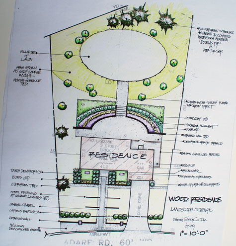
 This is stage 3 of the schematic plan. By schematic, I mean a plan that details only the big gestures and spaces. It does not tell you which pots to buy, or which cultivar of daylily to plant. That comes later. The big decisions get made first. Where do I want my grill, and my terrace? Where can my kids play? Could I host a large party in that spot? Where do I need shade? Where can I plant my vegetables?
The colorized version has another purpose besides just being fun to do. I color every plant that is the same, the same color. This will tell me instantly if I have too much going on, or not enough. Do I have more landscape than I can take care of? Grass is relatively easy to take care of-if it is a beautiful shape, that grass becomes landscape; the French call it a “tapis vert”. I can see the shapes of the spaces better in color; are they beautiful, as well as utilitarian, shapes? Does it look like my house sits in the middle of something bigger that it is? Does my house look like a home now? Could I imagine that the landscape came first, and the house was set down into it-rather than the other way around? Can I walk through the landscape, rather than on the edge of it?These are all good questions to ask in advance. You will then be ready for all of nature’s surprises, yet to come.

